

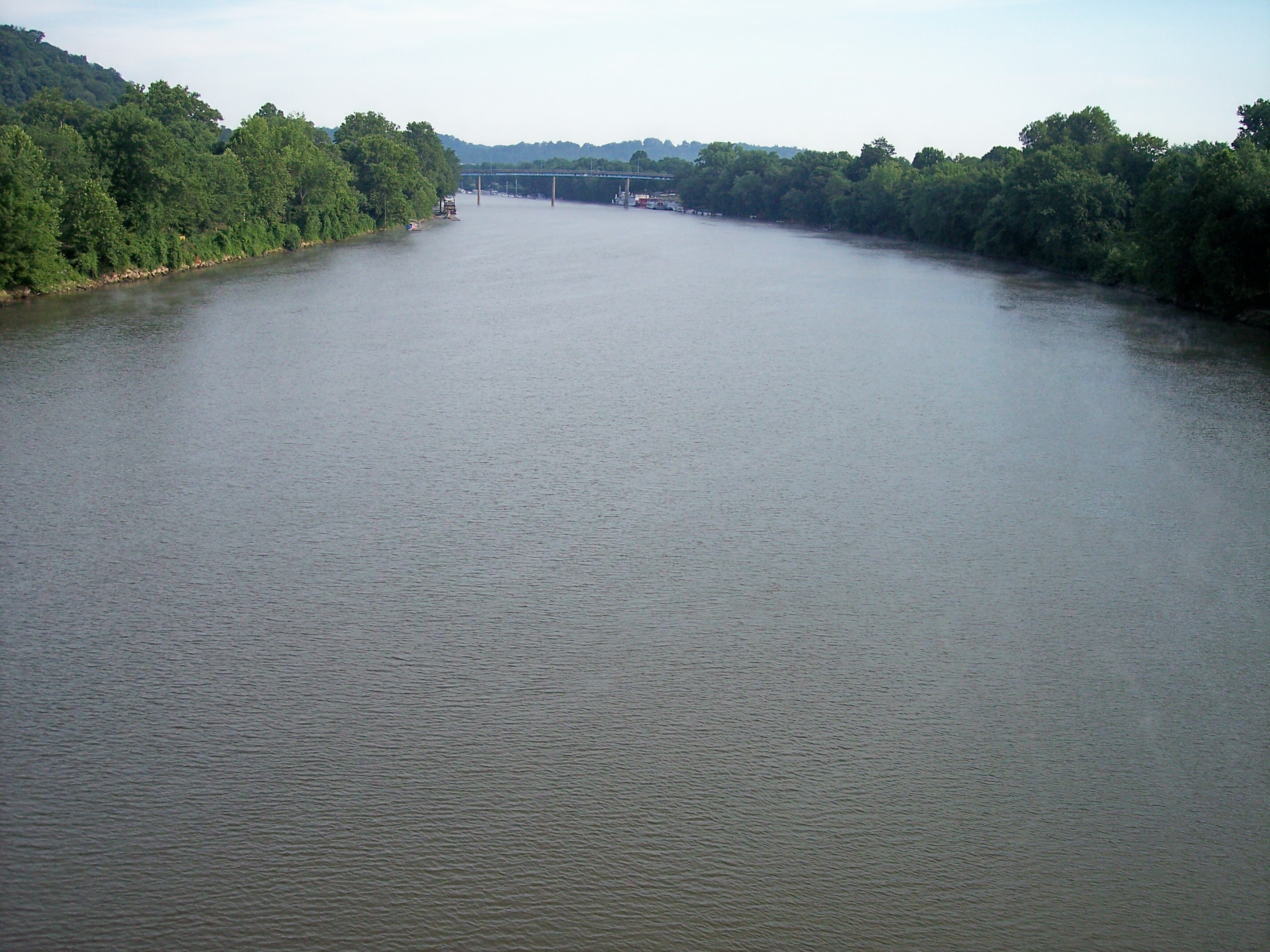
The famous rivers in Ohio are mainly based on their length, habitat, and sources. The famous Ohio River forms the southern border of the state.
The Cuyahoga River gained prominence after the great fire of 1969, which sparked environmental awareness. The Maumee River is popular as it is crucial for trade and shipping.
1. 10 Famous Rivers in Ohio You Should Know
Various renowned rivers surround Ohio. Here is the list of ten famous rivers in Ohio.
1.1. Ohio River
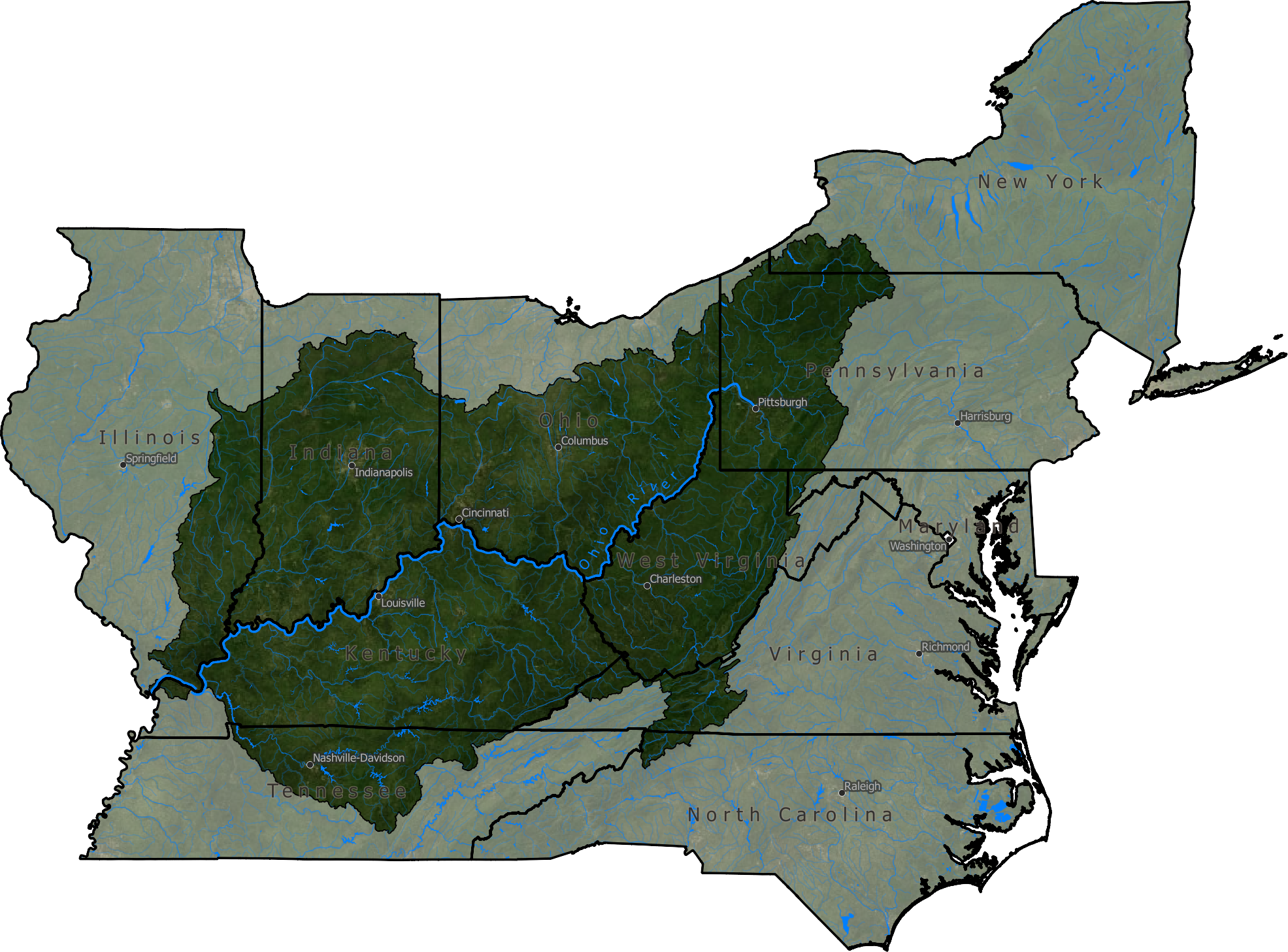
The Ohio River is a 1,579 kilometers long river in the United States. It flows from western Pennsylvania. Further, it ends in the Mississippi River at Cairo in Illinois. The river is formed through a confluence.
The confluence of the Monongahela River and the Allegheny River at Pittsburgh. Indiana-Kentucky, Ohio-West Virginia, Illinois-Kentucky, and Ohio-Kentucky are the main points marked by the river.
The river drains 528,100 square kilometers area of water in the Mississippi River. It is the longest and the largest river in Ohio.
Tributaries of the Ohio River are Kentucky, Tennessee, and Big Sandy. Also, the Green, Licking, Cumberland, and Kanawha rivers are southern rivers. Miami, Scioto, Muskingum, and Wabash are the northern tributaries.
The cities it covers in Ohio are Gallipolis, Louisville, and Cairo—also as Steubenville, Wheeling, Pittsburgh, Cincinnati, Marietta, and Portsmouth.
Huntington and Parkersburg cities are in West Virginia. Covington, Paducah, Ashland, and Owensboro cities are in Kentucky. Evansville, Mount Vernon, Madison, and New Albany cities are in Indiana.
1.2. Huron River

Huron River flows in the north-central Ohio, US. The 24-kilometre-long river is mainly located in Shiloh, Ohio. It drains the watershed of Lake Erie. Lake Erie lies in Huron County in Huron. East and West branches collide to form the river’s main branch. The main branch is near Milan.
51.2 kilometers long East Branch begins from Fitchville. It flows through North Fairfield. Further, it moves towards the north and streams in Peru and Norwalk.
Later, it reaches Milan. Meanwhile, the 87.7 kilometers long West Branch rises from Greenwich. From here, it flows through a long way before finally reaching Milan.
Its tributaries are Clayton Ditch, Sandhill Creek, and Marsh Run. Also, Mud Run, Shriner Run, Christiana Creek, and Frink Run. Further, it includes Jacobs Creek, Mud Brook, and Rattlesnake Creek. Cole Creek, Haas Ditch, and Walnut Creek are also the parts.
Moreover, Norwalk Creek, Milan Village Creek, and Megginson Creek. Finally, Old Woman Creek, Seymour Creek, and Slate Run are included.
1.3. Scioto River

The Scioto River lies in south-central Ohio in the United States. The 372-kilometre-long river begins in Hardin County in Ohio. Here, it goes with the Olentangy River. This is its biggest tributary. Further, it flows towards the South to meet the Ohio River. It meets the Ohio River at Portsmouth via Appalachian, Ohio.
However, it is quite a small river for today’s commercial craft. However, the Native Americans and early settlers used this river for shipping. The main significance of the Scioto River now is for drinking and recreation of water. Also, it is one of the longest rivers in Ohio, which flows completely within the state.
The river passes through Marion, Hardin, Ross, Scioto, Franklin, Pike, Pickaway, and Delaware counties. The Griggs Dam (1904 – 1908) and O’Shaughnessy Dam (1922 – 1925) were the two dams built on the river. Moreover, the Griggs Dam was first built in Columbus for water supply. Secondly, the O’Shaughnessy Dam created a huge reservoir in the US.
1.4. Great Miami River

The Great Miami River is one of the famous rivers in Ohio. The 260-kilometre-long river is the Ohio River’s tributary. It lies in Ohio and the state of Indiana in the US. The Great Miami River begins at the artificial Indian Lake. Further, it flows to the south. The route is via the Troy, Sidney, Middletown, Piqua, Dayton, and Hamilton cities.
It passes through Butler, Miami, Logan, Dearborn, Warren, Montgomery, Shelby, and Hamilton counties. This river is named after Miami.
Miami was a Native American who spoke Algonquian. It was during the days of European settlement. The river’s main stem starts from Indian Lake, which lies in Logan County.
Its tributaries are Twin Creek, Holes Creek, Wolf Creek, and Stillwater River. Further, Four Mile Creek, Mad River, Loramie Creek, and Whitewater River.
Moreover, Taylor Creek and Indian Creek are also included. The river has also been called many names. It includes Rocky Fiume, Assereniet River, Rocky River, and Riviere La Rushes, to name a few.
1.5. Sandusky River

Sandusky is a 214-kilometer-long river. It is a tributary in north-central Ohio to the Lake Erie. It flows into Lake Erie from the southwest side of Sandusky Bay.
The river has also been called Riviere Blanc, Potake Sepe, San-doo-stee River, and Riviere Sandusky. The data provide the list of names according to the Geographic Names Information System.
Its minor tributary is known as the Little Sandusky River. From the Brush Bridge in Marion County, it flows 22.5 kilometers towards the north. Later, it collides with the Sandusky River in Wyandot County.
Its watershed starts in Richland County. The Sandusky River flows via several counties. Out of which, Upper Sandusky, Fremont, and Tiffin are the most recognizable counties.
Early white settlers in Ohio used this river as a mode of transportation. Water transportation was much cheaper and more accessible than land transportation in that era.
1.6. Maumee River
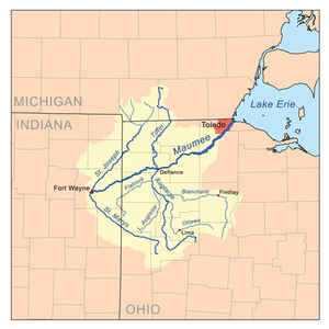
The Maumee River runs from the northeastern side of Indiana, United States. Further, it continues to northwestern Ohio. Moreover, it flows into Lake Erie.
Mainly, the river started by the confluence. It is the confluence of the St. Marys and St. Joseph Rivers. This confluence is near Fort Wayne, Indiana, US. It joins the Lake Erie via Maumee Bay.
The river is about 210 kilometers in length. The name Maumee is derived from the name Miami. It is the reference for an Indian tribe. Its primary tributary is the Auglaize River. Craig Memorial, Martin Luther King, and Anthony Wayne are the bridges that the river passes through.
The river crosses the following towns and cities:
- Toledo (Ohio)
- Perrysburg (Ohio)
- Antwerp (Ohio)
- Florida (Ohio)
- Maumee (Ohio)
- Oregon (Ohio)
- Cecil (Ohio)
- Napoleon (Ohio)
1.7. Wabash River

The Wabash River is an 810-kilometre-long river. It covers most of the part of Indiana State in the United States. Firstly, it begins from Ohio’s headwaters.
Then, via Indiana state, it continues towards Illinois, US. Before reaching the Ohio River, it forges the Indiana-Illinois border.
Wildcat Creek, Salamonie River, and White River. Also, the Patoka River, Sugar Creek, and Mississinewa River are the major left-side tributaries in Indiana.
Meanwhile, Eel, Tippecanoe, Little Rivers in Indiana, Embarras, Little Wabash, and Vermilion Rivers are in Illinois to the left. Moreover, Big Raccoon Creek and Little Vermilion River are also tributaries.
The river is the most significant Ohio River tributary to the north. It flows freely from the dam near Huntington, Indiana, to the Ohio River’s terminus. This is also known as the state river of Indiana. Its basin size is about eighty-six thousand square kilometers.
1.8. Mahoning River

The Mahoning River mainly lies in Ohio. But, a little section lies in Pennsylvania. It passes through many counties in Ohio. Then, it flows to Pennsylvania.
Later, it joins the Shenango River while forging the Beaver River. It starts in Winona, Ohio. The river is 182 kilometers in length.
Its basin size is about 2,932 square kilometers.
Following is the list of tributaries on the North Shore:
- Chocolate Run
- Dry Run
- Deer Creek
- Marshall Run
- Beech Creek
- Mosquito Creek
- Willow Creek
- Beaver Run
- Grays Run
- Kale Creek
- Little Squaw Creek
- West Branch
- Eagle Creek
Following is the list of tributaries on the South Shore:
- Fish Creek
- Mud Creek
- Hickory Run
- Duck Creek
- Island Creek
- Hines Run
- Fourmile Run
- Lawson Run
- Mill Creek (Berlin)
- Yellow Creek
- Meander Creek
- Charley Run Creek
- Mill Creek (Austintown)
1.9. Cuyahoga River

The Cuyahoga River is situated on the northeast side of Ohio. It divides Cleveland City and joins Lake Erie.
It passes through Portage, Summit, Cuyahoga, and Geauga counties in Ohio. Cuyahoga flows across Akron, Kent, Cuyahoga Falls, and Cleveland cities. The river is 136.6 kilometers in length.
This river begins from the confluence of West Branch Cuyahoga River and East Branch Cuyahoga River.
It lies in Burton, Geauga County, Ohio, United States. Finally, it joins its mouth at Lake Erie in Cleveland, Cuyahoga County, Ohio. Its basin size is 2,100 square kilometers.
Various names call the river. Following are the names of the Cuyahoga River:
- Gwahago River
- Cajahage River
- Goyahague River
- Gichawaga Creek
- River De Saguin
- Cuyahoga River
- Yashahia
- Kiahagoh River
1.10. Muskingum River
The Muskingum River is 179 kilometers long. It is a tributary of the Ohio River. It starts from the confluence. It is of the Walhonding River and Tuscarawas River.
Further, it flows through Conesville, Zanesville, Philo, Malta, Beverly, Devola, etc. Moreover, it joins its mouth, the Ohio River, at Marietta in Ohio. The size of the basin is 20,850 square kilometers.
Below is the list of its variant names:
- Riviere Chiagnez
- Big Muskingum River
- Muskingum River
- Mouskindom River
- Elk River
The above data is based on the Geographic Names Information System.
Bottomline
Ohio is a notable state in the United States. This state itself gets its name from the Ohio River. The state forms an intricate tapestry that weaves history, commerce, and ecology together. From the iconic Ohio River to the majestic Cuyahoga, these waterways have formed the state’s identity.
Last Updated on by Narayani Bhardwaj


